thegoldenadventure.com

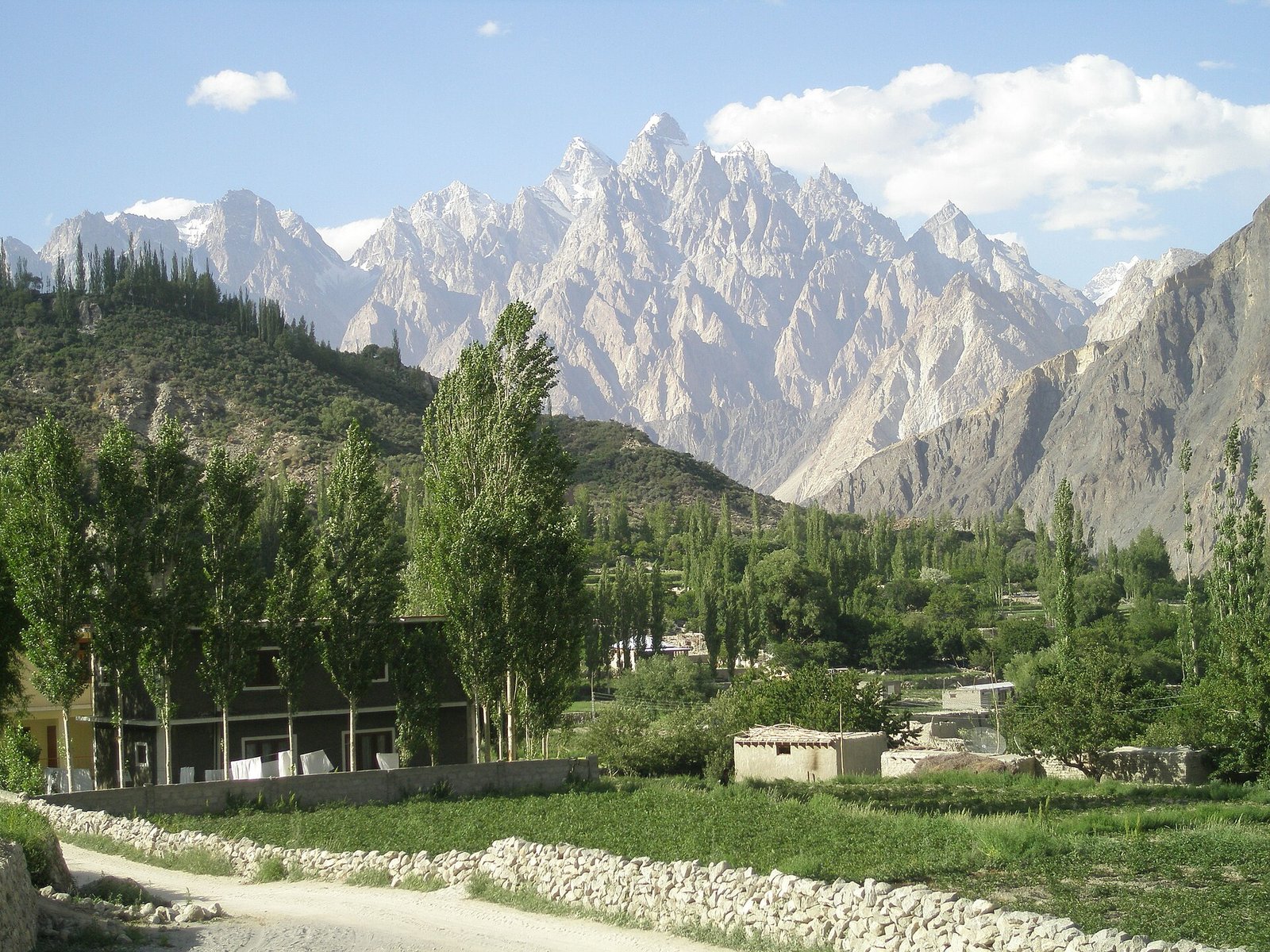
Upper Hunza: Gulmit village in Gojal with the Karakoram peaks behind
Destination guide

Upper Hunza: The Complete Gojal Travel Guide

Above Attabad Lake the Karakoram Highway enters Upper Hunza, a high, open valley of Wakhi villages, saw-toothed peaks and some of the longest glaciers outside the polar regions. It is the stretch of the Silk Road most travellers remember longest.

Updated October 2026By The Golden Adventure team
Photo: Baqhusbti / Wikimedia Commons, CC BY-SA 3.0 (source)

Upper Hunza at a Glance

Upper Hunza, known locally as Gojal, runs from Attabad Lake to the Chinese border at the Khunjerab Pass. Its villages – Gulmit, Ghulkin, Hussaini, Passu and Sost – are bases for glacier walks, short treks and the drive to the highest point of the Karakoram Highway.

LocationGojal sub-division, Hunza District, Gilgit-Baltistan
AltitudeAbout 2,400–2,600 m in the main villages; Khunjerab Pass 4,693 m
Best time to visitMay–October; autumn colour in late October
Getting thereFly to Gilgit, then about 3–4 hours north on the Karakoram Highway
Top sightsAttabad Lake, Passu Cones, Hussaini Bridge, Borith Lake, Batura Glacier
Known forWakhi culture, glaciers, Silk Road scenery

Where Is Upper Hunza?

Upper Hunza is the northern part of Hunza District in Gilgit-Baltistan, beginning roughly where the Karakoram Highway emerges from the tunnels beside Attabad Lake. From there the road climbs through Gulmit, Hussaini, Passu and Sost to the Khunjerab Pass on the Chinese border. To the north-west, the Chapursan valley reaches the edge of Afghanistan’s Wakhan corridor.

Gulmit, the administrative centre, sits at about 2,408 m. Passu is around 20 km further north and roughly 147 km from Gilgit by road. Sost is the last town before China and hosts the customs and immigration post; the pass itself is about 75 km beyond it. Side valleys lead east to Shimshal and west into Chapursan.

In 2019 Gojal was made a separate sub-division of Hunza District, and it is the largest sub-division in Gilgit-Baltistan.

History & People of Upper Hunza

Gojal was part of the old princely state of Hunza, but its people are mostly Wakhi, whose ancestors came over the passes from the Wakhan region. Wakhi is the main language, although Burushaski is spoken in Shishkat and in parts of Chapursan. The population is overwhelmingly Ismaili Muslim, and village life is shaped by community organisations, schools and a strong culture of volunteering.

The modern history of the valley is defined by the Karakoram Highway and by geology. On 4 January 2010 a huge landslide at Attabad killed 20 people and blocked the Hunza River, creating a lake that drowned parts of Shishkat and Gulmit and cut the highway for years. Five tunnels totalling about 7 km, the Pakistan–China Friendship Tunnels, reopened the route in September 2015.

MUST-SEE EXPERIENCES

Top 10 Things to Do in Upper Hunza

From turquoise lakes to rope bridges, these are the highlights of Gojal.

  1. 01
    Nature

    Take a boat on Attabad Lake

    The lake formed by the 2010 landslide is about 21 km long and over 100 m deep, with startling turquoise water in summer. Boats and jet skis run from the jetties near the tunnels. Lake conditions and boat services vary with the season.

  2. 02
    Viewpoint

    Photograph the Passu Cones

    The serrated spires of Tupopdan (6,106 m), better known as the Passu Cones, rise straight above the highway near Passu. Sunrise and late afternoon give the best light.

  3. 03
    Adventure

    Cross the Hussaini Suspension Bridge

    This narrow plank-and-cable bridge over the Hunza River is one of the most photographed sights in the valley. It sways and has wide gaps, so cross slowly, one group at a time, and skip it if you are uneasy with heights.

  4. 04
    Nature

    Walk to Borith Lake

    Below Hussaini village, Borith Lake is a small saline lake at about 2,600 m with views of the surrounding peaks. It is a quiet spot for birdwatching and a pleasant start or finish for walks towards the Ghulkin Glacier.

  5. 05
    Adventure

    Trek to Patundas Meadows

    Usually a three-day trip from Passu, the Patundas trek crosses the Passu Glacier to high meadows at roughly 4,100–4,300 m. The views over the Passu and Batura glaciers are among the finest in the region; a local guide is essential for the glacier crossing.

  6. 06
    Adventure

    Explore the Batura Glacier

    Just north of Passu, the Batura Glacier is about 56–57 km long, one of the longest outside the polar regions. Multi-day treks follow its edge past summer herders’ huts.

  7. 07
    Culture

    Wander Gulmit and the Ondra ruins

    Gulmit’s old lanes and the ruined walled settlement of Ondra above the village give a 360-degree view from Shishkat to Passu. It is a good place to slow down and see Wakhi village life.

  8. 08
    Nature

    Walk on the Ghulkin Glacier

    A short guided walk across the Ghulkin (Hussaini) Glacier – about 2.5 km of moraine and ice – links Ghulkin and the Borith area. Go with a local guide, as the surface shifts every season.

  9. 09
    Viewpoint

    Drive to the Khunjerab Pass

    At 4,693 m, the Khunjerab Pass on the Chinese border is the highest point of the Karakoram Highway. The road crosses Khunjerab National Park, where you may spot ibex and marmots.

  10. 10
    Culture

    Venture into Chapursan

    The Chapursan valley west of Sost is remote Wakhi country, ending at Zood Khun near the Afghan border. Basic family guesthouses offer a glimpse of life far from the highway.

Best Time to Visit Upper Hunza

May to October is the best window. Late spring brings blossom to Gulmit and Passu, summer is warm by day and ideal for treks, and the second half of October turns the poplars and orchards gold. The Khunjerab Pass usually opens around 1 April and closes around 30 November, though snow decides the exact dates.

Winter is very cold, with frequent power cuts and closed guesthouses, but parts of Attabad Lake can freeze and the light is crisp. July and August bring the most flood risk: in August 2025 a glacial outburst from the Shishper Glacier washed away a section of the highway near Hassanabad, cutting the road north for a time.

How to Get to Upper Hunza

Fly from Islamabad to Gilgit (weather-dependent) and drive north on the Karakoram Highway, or travel the whole way by road. From Karimabad or Aliabad, Gulmit is roughly an hour away.

RouteDistanceTypical time
Gilgit – GulmitAbout 125–140 km3–4 hours
Aliabad – HussainiAbout 45 kmAbout 1 hour
Gilgit – PassuAbout 147 km3.5–4 hours
Sost – Khunjerab PassAbout 75 kmAbout 2 hours
Passu – ShimshalAbout 56 km3–4 hours by jeep

Times are approximate and depend on roadworks, landslides and checkpoints.

Getting Around Gojal

The main villages all sit on or just off the Karakoram Highway, so a private car with driver makes it easy to stop at viewpoints and bridges. Public minivans run between Aliabad and Sost, but services are irregular. Side trips to Shimshal and Chapursan need a 4×4 on unpaved tracks.

Where to Stay: Gulmit, Passu or Sost

Gulmit and Passu have the widest choice of small hotels and guesthouses, many with views of the Passu Cones or the river. Sost has functional lodging aimed at border traffic. In Chapursan and Shimshal, expect simple family guesthouses with floor mattresses and limited electricity. Book ahead for late October, the peak photography season.

Suggested Upper Hunza Itineraries

Two days

Day 1: Attabad Lake, Gulmit and the Hussaini Bridge, overnight in Passu. Day 2: Khunjerab Pass and back to Karimabad.

Four days

Add Borith Lake and the Ghulkin Glacier walk, plus a day hike towards the Batura or Passu glacier viewpoints.

One week

Combine the highlights with the three-day Patundas trek or two nights in Shimshal. Build in a spare day for weather.

What to Pack for Gojal

  • Warm layers and a windproof jacket; Khunjerab is cold even in July.
  • Sunglasses and strong sunscreen for high-altitude sun.
  • Sturdy walking shoes with grip for moraine and the bridges.
  • Modest clothing and a scarf for women.
  • Cash, a head torch and a power bank for power cuts.

Culture & Etiquette

Wakhi communities are welcoming to visitors. Dress modestly, ask before photographing people, and remove shoes when entering homes. Jamatkhanas (Ismaili prayer halls) are not tourist sites, so do not enter without an invitation.

Practical Travel Tips for Upper Hunza

Safety and advisories: Gilgit-Baltistan is not among the areas on the US State Department‘s Do Not Travel list, though Pakistan overall is rated Level 3. The UK FCDO advises against all travel on the Karakoram Highway between Mansehra and Chilas, south of Gilgit. Natural hazards – landslides, floods and altitude – are the main day-to-day risks here.

Permits: Gulmit, Passu, Sost and the Pakistani side of Khunjerab are open to foreigners with a valid visa. Register at police checkpoints. Some areas near the borders, such as the Baba Ghundi shrine in Chapursan, have required an NOC; check current rules before you go.

Money and signal: ATMs are limited, so bring enough cash from Gilgit or Aliabad. Mobile signal is weak in places.

UPPER HUNZA TRAVEL

Upper Hunza Highlights at a Glance

Upper Hunza combines easy roadside sights – Attabad Lake, the Passu Cones and the Hussaini Bridge – with glacier treks and the high road to China.

Visit from May to October, base yourself in Gulmit or Passu, and allow at least two nights to enjoy the valley at a gentle pace.

For background on the valley’s geography and villages, see Gojal on Wikipedia.

Plan your Upper Hunza trip

Upper Hunza FAQs

What is the difference between Hunza and Upper Hunza?

Upper Hunza, or Gojal, is the northern part of Hunza District above Attabad Lake. Its people are mainly Wakhi, while central Hunza around Karimabad is mainly Burushaski-speaking.

How many days do I need in Upper Hunza?

Two days covers the main sights and Khunjerab. Four to seven days lets you add glacier walks, Patundas or Shimshal.

Is Upper Hunza safe?

Gilgit-Baltistan is not on the US Do Not Travel list, and Gojal is generally peaceful. Pakistan overall is rated Level 3 by the US, and the UK FCDO advises against the KKH between Mansehra and Chilas. Landslides and floods are the bigger practical risks.

Is the Hussaini Bridge dangerous?

It is not for everyone: the planks are widely spaced and the bridge sways. Cross slowly, in small numbers, and avoid it in strong wind.

When is the Khunjerab Pass open?

Usually from about 1 April to 30 November, though the dates depend on snow each year.

Do foreigners need a permit for Gojal?

No special permit is needed for the main villages or the Pakistani side of Khunjerab. Some border areas, such as Baba Ghundi in Chapursan, have required an NOC.

Can I visit Gojal in winter?

Yes, but expect severe cold, power cuts and closed hotels. Attabad Lake can partly freeze, and the Khunjerab Pass is closed.

TGA AI AssistantOnline · usually replies in seconds
AI can make mistakes. Please don't share personal, passport or card details.