thegoldenadventure.com

Kumrat Valley in Upper Dir, Khyber Pakhtunkhwa
Destination guide

Kumrat Valley: The Complete Travel Guide

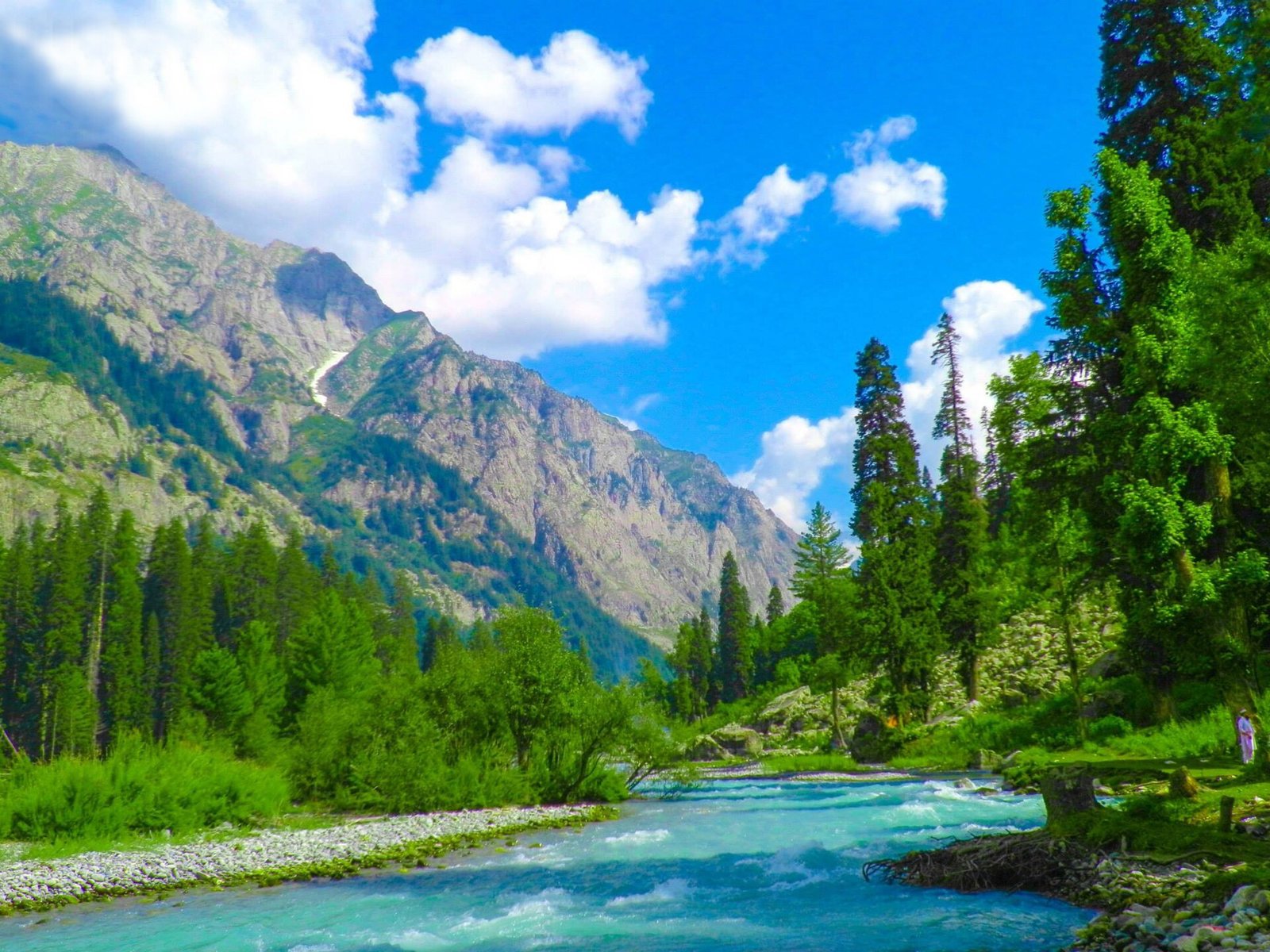
Kumrat Valley is the forested upper Panjkora valley in Upper Dir, famous for deodar woods, riverside camping and the meadows of Jahaz Banda.

Updated October 2026By The Golden Adventure team
Photo: Salman Shah / Wikimedia Commons, CC BY-SA 3.0 (source)

Kumrat Valley at a Glance

Kumrat Valley sits at the head of the Panjkora River in Upper Dir, beyond the village of Thal. Its deodar forest, waterfalls and alpine meadows have made it one of the busiest summer destinations in Khyber Pakhtunkhwa for Pakistani visitors. Foreign travellers should know that the US and UK both currently advise against travel to Upper Dir.

LocationUpper Dir District (Sharingal tehsil), Khyber Pakhtunkhwa
AltitudeJahaz Banda meadow about 3,100 m; Badgoi Pass 3,523 m
Best time to visitJuly to September
Getting thereRoad to Upper Dir and Thal, then about 45 km by 4×4
Top sightsDeodar forest, Kala Chashma, waterfalls, Jahaz Banda, Katora Lake
Known forRiverside camping; US and UK advise against travel

Where Is Kumrat Valley?

The Kumrat Valley is the upper part of the alpine Panjkora valley in Upper Dir District, Khyber Pakhtunkhwa. Wikipedia places it in Sharingal tehsil, in the region known as Upper Dir Kohistan, covering about 346 km². On the far side of the mountains lies the Gabral area of Swat Kohistan.

Thal (often spelled Thall) is the gateway village, with a bazaar and a police check post. From Thal an unpaved road follows the Panjkora about 45 km north into the forest. To the east, the Badgoi Pass (3,523 m) links the valley with Utror and Kalam in Swat, and a cable car to Madaklasht in Lower Chitral has been proposed but not built.

People & Nature of Kumrat Valley

The valley is mainly home to the Gawri people, who speak the Gawri language, a Dardic tongue shared with Kalam across the pass. Life revolves around livestock, small fields and the forest, and winters are long and harsh.

The forest is the valley’s defining feature. Wikipedia lists blue pine, deodar, West Himalayan fir and Himalayan birch in the upper section and oaks lower down, with wildlife including Asiatic black bear, musk deer and Astor markhor. It also notes that deodar forest is shrinking because wood is burned for heating and cooking in winter, so visitors should never cut trees for campfires.

Tourism has grown fast. Arab News, citing provincial figures, reported more than 2.6 million visits between September 2023 and August 2024, including 533 foreigners.

MUST-SEE EXPERIENCES

Top 8 Things to Do in Kumrat Valley

These are the sights most visitors head for, from the riverside forest to the high meadows.

  1. 01
    Nature

    Camp in the deodar forest

    Level ground beside the Panjkora is shaded by tall deodar trees, and simple camps operate in summer. Waking to mist over the river is the classic Kumrat experience.

  2. 02
    Nature

    Visit Kala Chashma

    Kala Chashma, the ‘Black Spring’, is one of the valley’s best-known sights near the head of the road, with waterfalls nearby. Expect crowds at peak times.

  3. 03
    Adventure

    Hike to Jahaz Banda meadow

    Jahaz Banda is a large meadow at about 3,100 m surrounded by forest and snow peaks. One route reaches it by jeep to Jandrai or Takai Top, then a walk of about two hours.

  4. 04
    Adventure

    Trek on to Katora Lake

    Above Jahaz Banda, a moderate trek of about three to three and a half hours leads to Katora Lake, a glacial lake in a high bowl. Start early to avoid afternoon weather.

  5. 05
    Nature

    Follow the Panjkora River

    The river splits into channels across the valley floor, making easy riverside walks. Never camp on gravel bars; water levels rise quickly after rain.

  6. 06
    Culture

    Stop in Thal village

    Thal is the gateway village and a natural lunch stop, with wooden houses, a bazaar and fields along the river.

  7. 07
    Adventure

    Drive the Badgoi Pass to Kalam

    In late summer a rough jeep road crosses the 3,523 m Badgoi Pass to Utror and Kalam. In June 2024 local authorities cleared it early, cutting the crossing to about two hours.

  8. 08
    Nature

    Look for wildlife

    Black bear, foxes and musk deer live in the forests, though sightings are rare. Early mornings away from the busy camps give you the best chance.

Best Time to Visit Kumrat Valley

The season is short. Visitors generally come from about July to September, after the snow clears and while the upper meadows are green. The Badgoi Pass is usually closed by snow for five to six months of the year and normally reopens in late June or July.

Summer is also monsoon season. Heavy rain in August 2024 washed away the main road at Barikot and three bridges between Makrala and Thal, and authorities evacuated about 250 stranded tourists. Eid holidays bring very large domestic crowds; Wikipedia notes around 2,000 vehicles a day entering at Eid al-Fitr.

MonthsConditions
May–JuneSnow on high ground; Badgoi Pass usually closed
July–AugustPeak season, monsoon storms and flood risk
SeptemberQuieter, cold nights, fewer camps open
October–AprilCold and snowy; not recommended

How to Get to Kumrat Valley

From Islamabad the usual route runs north through Malakand and Lower Dir to Upper Dir, then on to Thal. A 2026 report by APP said the road from Patrak to Thal bazaar still needed urgent repair. From Thal, a 4×4 is essential.

RouteDistanceTypical time
Dir – Thal–6–8 hours by shared taxi (2019 traveller report)
Thal – Kumrat forestAbout 45 km1–2 hours by jeep
Kalam – Utror – Badgoi Pass – Thal–About 5 hours in a 2019 report; summer only
Jahaz Banda – Katora Lake–3–3.5 hours on foot

Getting Around

The road beyond Thal is unpaved and passable only by four-wheel-drive vehicles. Hire a local jeep and driver in Thal, agree the route and waiting time in advance, and avoid driving after dark or in heavy rain.

Where to Stay

Options are basic. Thal has a few hotels and guesthouses, and in the forest most visitors use seasonal tent camps or their own tents. APP reported in July 2026 that hotels and inns fill up in peak summer and that locals were calling for regulated prices and more facilities. Bring a warm sleeping bag; nights are cold even in July.

Suggested Itineraries

3 days (only if advice allows)

Day 1 travel to Thal. Day 2 jeep into the forest, visit Kala Chashma and camp by the river. Day 3 return to Thal and onward.

5 days with Jahaz Banda

Add two days for the walk to Jahaz Banda and a day trek to Katora Lake.

Kalam loop

Cross the Badgoi Pass from Utror to Thal and return via Dir, combining the valley with Kalam Valley.

What to Pack

  • Tent or confirmed camp booking, plus a warm sleeping bag
  • Waterproof jacket and quick-dry layers
  • Trekking shoes for Jahaz Banda and Katora Lake
  • Headtorch and power bank; electricity is limited
  • Cash; there are no reliable ATMs beyond Dir
  • Rubbish bags to carry out waste
  • Modest clothing and a scarf for women

Combine Kumrat Valley with Nearby Destinations

The natural partner is Kalam over the Badgoi Pass, then the main Swat Valley. If US or UK advice rules out Upper Dir for you, Gilgit-Baltistan has similar forests, meadows and lakes, for example in Ghizer and Phander. Note that Chitral is also in Khyber Pakhtunkhwa and falls under the same US warning.

Culture & Etiquette

Upper Dir is very conservative. Dress modestly, ask before photographing anyone, and never photograph women. Mixed foreign groups and solo women attract attention, so travel with a local guide. Respect prayer times and keep music low near villages.

Practical Travel Tips for Kumrat Valley

Travel advisories: read this first

The US State Department rates Khyber Pakhtunkhwa at Level 4, Do Not Travel, “for any reason due to terrorism and kidnapping”. The UK FCDO advises against all travel to Upper Dir and Lower Dir, both on the road to the valley, and against all but essential travel to Malakand. Travel insurance may not cover you. Read the US advisory and FCDO advice, and our Is Pakistan safe? guide.

Permits and checkpoints

There are security checkpoints on the way, including one between Thal and the forest. A 2019 traveller reported being told foreigners could stay only in an army guest house or with a local companion. The US advisory also notes special permit rules for foreigners in parts of the province; see our NOC guide and ask us for current requirements.

Floods

Follow weather alerts and never camp close to the river during rain. Read about the August 2024 rescue in Arab News.

Money and signal

Carry cash. Mobile coverage is limited in the upper valley.

KUMRAT VALLEY TRAVEL

Kumrat Valley Highlights at a Glance

Kumrat Valley is all about the forest: deodar and pine running down to a braided river, with meadows and a glacial lake above for those who walk.

It is busy, rough around the edges and seasonal, and for foreign visitors the strict US and UK advice is the deciding factor.

For a recent snapshot of the valley in the monsoon, see APP’s July 2026 report.

Plan your Kumrat Valley trip

Kumrat Valley Tours with The Golden Adventure

We do not run a fixed Kumrat departure. Our team can talk you through the current situation and, where appropriate, compare it with our jeep safari tours and trekking tours in Gilgit-Baltistan, which offer similar forests, meadows and lakes.

Plan your trip

Tell us your dates and interests and our team in Gilgit will design a private trip and send your free Letter of Invitation.

Kumrat Valley FAQs

Is Kumrat Valley safe for foreigners?

Official advice is strict. The US rates all of Khyber Pakhtunkhwa at Level 4, Do Not Travel, and the UK FCDO advises against all travel to Upper and Lower Dir. Your insurance may not apply. Read both advisories before making any plans.

Where is Kumrat?

In Upper Dir District, Khyber Pakhtunkhwa, at the head of the Panjkora River, about 45 km north of Thal.

Do I need a 4×4?

Yes. The road beyond Thal is unpaved and Wikipedia notes it is passable only by four-wheel-drive vehicles.

When is the best time to visit?

July to September. Before then snow blocks the high ground and the Badgoi Pass; after September it turns cold and camps close.

How high is Jahaz Banda?

About 3,100 m. Katora Lake lies a further three to three and a half hours’ walk above it.

Can I travel from Kalam to Kumrat?

Yes, in summer, by jeep from Utror over the Badgoi Pass (3,523 m) to Thal. The pass is snowbound for much of the year.

Where do visitors stay?

In simple hotels in Thal, or tent camps and guesthouses in the valley. Book ahead in peak season and bring warm bedding.

TGA AI AssistantOnline · usually replies in seconds
AI can make mistakes. Please don't share personal, passport or card details.